
These parts of L.A. are now considered a very high fire hazard, according to a new map

Roughly every decade, CalFire releases a new map that outlines exactly which areas of California are within fire hazard zones: pieces of property that, due to a mix of fuel, terrain and weather, face the heightened possibility of fire conditions.
The state’s map was last revised in 2011, but after this January’s devastating Palisades and Eaton fires, Governor Gavin Newsom ordered a prompt update to the map—and after a phased rollout, the information for Southern California was released earlier this week.
As you might expect, the new maps are a bit bleak, with thousands of additional acres now considered a fire hazard compared to 14 years ago. You can see a full, interactive version of the map on CalFire’s website, as well as an overview below and a rundown of what you need to know.

What the new L.A. fire hazard map shows
For starters, it measures “hazard” and not “risk”—in other words, the probability that an area could see fire, not an indication of how much damage fire could cause there.
In addition, though the 2011 version of the map simply identified “very high” hazard areas, the 2025 revision adds “moderate” and “high” categories, as well. According to ABC, there’s been a 29% increase in “very high hazard” areas alone in L.A. County, plus thousands of additional acres that’ve been designated one of the lower tiers.
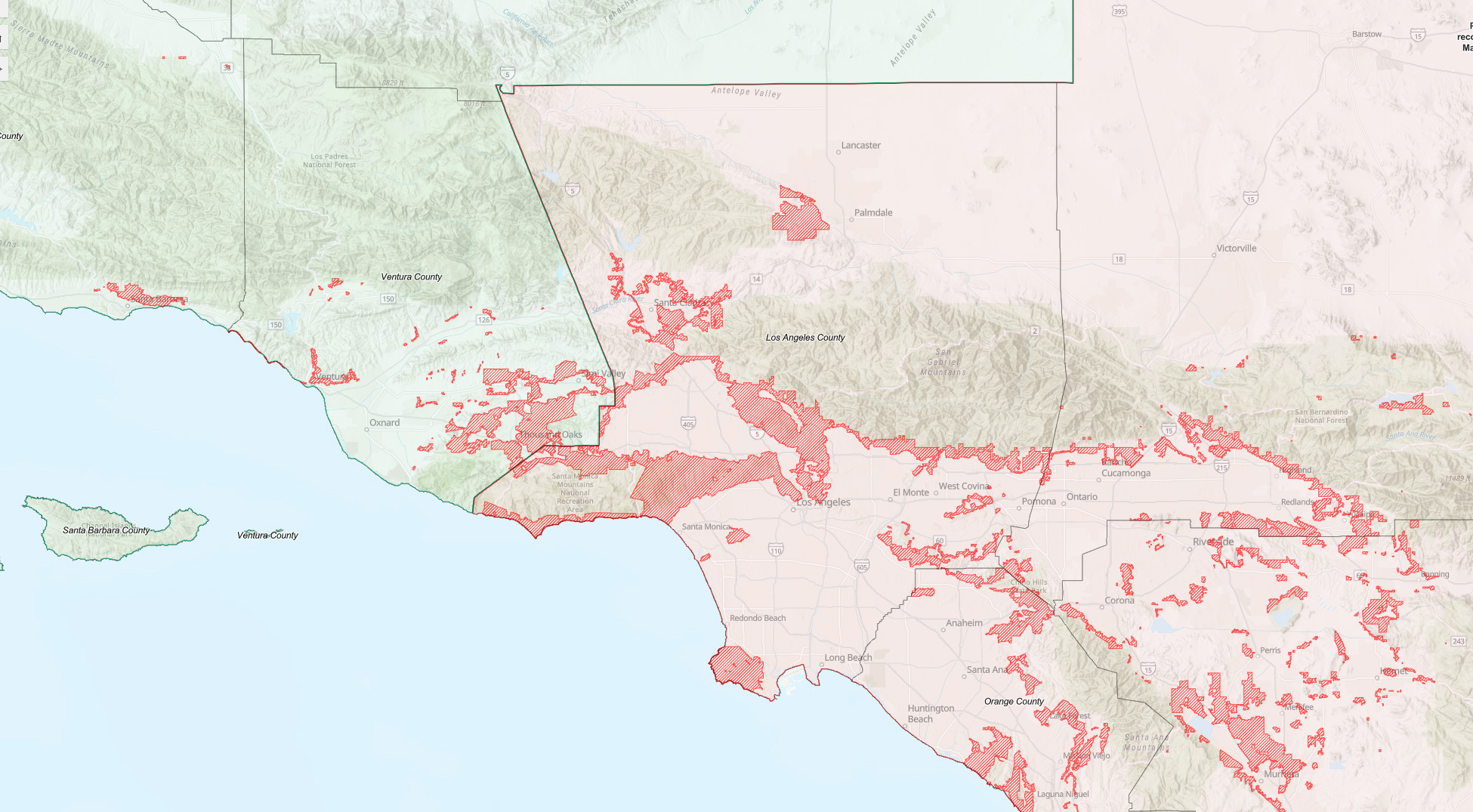
Which neighborhoods face the highest severity of fire hazards?
Basically any mountain or hillside in Los Angeles county is considered a “very high” hazard, and since the 2011 edition of the map, those areas have slightly swollen with a fringe of “high” and “moderate” areas.
Nearly all of the Santa Monica Mountains and Hollywood Hills are considered “very high,” as are foothill communities along the San Gabriel Mountains—which together include most of the area that was impacted by the Palisades Fire, but only the northernmost edges of the Eaton Fire’s burn area in Altadena (again speaking to the fact that these maps identify probability and not damage). All of Malibu is labeled “very high” as is most of Silver Lake, Echo Park and Northeast L.A.
The most notable change in the map comes on the other side of the San Gabriels toward Lancaster and Palmdale, where most of the Antelope Valley is now listed as “moderate,” and some of the desert areas closer to mountains—including the Antelope Valley Poppy Reserve—are now listed as “very high.” And over in Ventura County, nearly all of the communities along the Santa Clara River are now in hazard areas.
There are some smaller changes here and there across the map; some patches in Granada Hills and the hills west of Whittier Narrows have been added, though the area between Playa del Rey and Ballona Creek has been removed. Palos Verdes is still considered a hazard, though the peninsula’s impacted areas are now more targeted than the 2011 version.
What this means for homeowners and renters
Now that CalFire has released the maps, local governments will have 120 days to adopt—and potentially add area to—the new zones. Regardless of local laws, the state requires homeowners in “very high” hazard areas to clear or trim native brush, weeds, grass, trees and hazardous vegetation within 200 feet of any structures or buildings, and within 10 feet of any combustible fence or roadway.
Why the maps changed in 2025
In addition to the legal explanation for the “why”—Newsom’s previously mentioned executive order—the maps were updated to reflect the realities of climate change’s impacts on California. CalFire notes that its hazard mapping process has “incorporated new science in local climate data and improved fire assessment modeling” into its 2025 ratings.
Categories
Recent Posts


